Ridgewood Manor History
How seventy-eight homes came to occupy 21.66 acres on the western edge of Upper St. Clair Township — from a nineteenth-century farm to a recorded plan of lots, told through historical aerials, township approvals, and historical maps.
The Township: A Brief History of Upper St. Clair
The name “Upper St. Clair” traces back to General Arthur St. Clair (1737–1818), a Scottish-born officer who crossed the Atlantic in 1755 and eventually settled in the Ligonier Valley. St. Clair fought in both the French and Indian War and the Revolutionary War, and in 1787 he held the office of President of the Continental Congress — the presiding officer of the United States under the Articles of Confederation — from February to October of that year. His presidency was brief but consequential: the Congress under his direction passed the Northwest Ordinance and finalized the framework that led to the Constitution. He later served as the first Governor of the Northwest Territory.
When the Pennsylvania General Assembly created Allegheny County in 1788 and organized it into seven townships, the broad swath of land south of Pittsburgh was designated St. Clair Township in his honor. European settlers had already been present for a generation — John Fife, considered the first European settler in the area that is now Upper St. Clair, arrived around 1762 near the intersection of Washington and McLaughlin Run Roads, nearly a quarter century before the county itself was organized.
As population grew and priorities diverged between the more urbanized north of the township and the still-rural south, local interests pushed for a split. In 1836, St. Clair Township was formally divided: the denser northern portion became Lower St. Clair Township, and the rural southern section became Upper St. Clair Township. The residents who formed Upper St. Clair were seeking local governance better suited to an agricultural community than the combined township could provide.
What happened to Lower St. Clair?
Nearly every new Upper St. Clair resident eventually asks the question. Lower St. Clair Township — which originally encompassed the area from Chartiers Creek east to Streets Run, including what is now Pittsburgh’s South Side — was subdivided repeatedly as Pittsburgh expanded southward. Boroughs formed, wards were annexed, and the city grew outward. Piece by piece, Lower St. Clair’s territory was absorbed by other municipalities until, by 1920, the township had ceased to exist entirely. The St. Clair name survives today only as a small Pittsburgh neighborhood on the South Side slopes, but Lower St. Clair Township itself is long gone. Upper St. Clair, by contrast, remained rural enough — and later suburban enough — to preserve its identity as an independent municipality. The township adopted a home rule charter in 1973, which took effect in January 1976.
Historical Aerials
The land that became Ridgewood Manor has been photographed from the air at regular intervals since the late 1930s. Click any thumbnail to open a before-and-after slider — drag the handle to overlay the modern neighborhood boundary onto the historical image.
For most of two centuries this ground was farmland — most recently the Gilfillan family farm. The Gilfillan siblings sold it in December 1964, and after a series of transfers the developer Broadlawn Highlands Corporation platted it as Ridgewood Manor in 1977, establishing 78 homes on 21.66 acres.
Platting the Neighborhood: The 1977 Approval
What had been farmland for two centuries became Ridgewood Manor over a single year of public hearings, engineering reviews, and township votes in 1977. The developer was Broadlawn Highlands Corporation — the renamed Morrow Road Corporation that had held the ground since 1968 — represented at the hearings by John Hall. Broadlawn Highlands filed its application on January 10, 1977; the Township Planning Commission reviewed it through January and February and recommended approval by a 5–2 vote. The Board of Commissioners held public hearings on March 21 and April 11, 1977, granted tentative approval on May 2, 1977 (Decision USC PRD 1-77), and gave final approval by Ordinance 703 on June 20, 1977. The plan of lots was recorded with Allegheny County on September 29, 1977. The houses themselves were built by Ryan Homes, Inc., under an agreement with the developer.
Ridgewood Manor was not a conventional subdivision but a Planned Residential Development (PRD) — a then-novel mechanism under Pennsylvania’s Municipalities Planning Code that the Township’s 1975 Comprehensive Plan had specifically endorsed as “cluster zoning.” The idea was to let a developer reduce individual lot dimensions in exchange for setting aside common open space, keeping the overall density low. The recorded plan placed 78 single-family lots on 21.66 acres of a 27.99-acre development site — a density of 2.79 dwellings per acre — with the balance given over to streets and roughly two and a half acres of common open space threaded by a system of pedestrian walkways. The plan provided two tennis courts and a tot lot, and established a Homeowners Association to maintain the shared grounds. Because the site sat in an R-2 single-family district, the Board had to grant formal variations from the zoning code to permit the tighter cluster layout: a minimum lot width of 78 feet, 30-foot front yards, and side yards of five and ten feet — in place of the code’s standard 13,000-square-foot lots and wider setbacks. Homes were projected to sell for an average of $60,000 (a minimum of $50,000), and the new neighborhood was expected to add about 295 residents and 94 schoolchildren to the township.
This was not the first plan drawn for the ground. An earlier proposal for the same site, called Timber Glen, had included “diverse units” — a mix of housing types beyond single-family homes — and neighbors had opposed it during hearings. Broadlawn Highlands came back with an all-single-family plan, citing both the neighborhood opposition and the economics of the lots. The Board found the development compatible with its surroundings, which the 1977 record lists as Mayview State Hospital, a fire-department substation, the county regional park, and the single-family homes along Lattidome, Giant Oaks, and Woodsdale Drives and Hastings Mill Road.
The commissioners noted the site’s distinctive “bowl” shape — its views are mostly interior, with the surrounding streets looking down into the hollow that the neighborhood now fills. The land carried the legacy of the coal era: the northern and southern thirds of the site had been undermined. The developer’s engineers reported enough rock overburden above the old workings — on the order of 207 to 287 feet — to support the houses, but tentative approval required the developer to inform every prospective buyer that the area had been undermined, to reimburse the township for any costs arising from landsliding or mine subsidence, and to engineer foundations for the slide-prone, clay-bearing slopes.
One condition of approval has a poignant ending. A grove of domestic cherry trees near Lots 21 and 22 had been identified as unique, and tentative approval directed the developer to work with the Township Forester on a plan to preserve it — even requiring the final site plan to show the grove protected. By the time final approval came that June, however, the Board concluded the grove could not be saved: Ordinance 703 records that it “cannot be preserved without destroying the integrity of the Planned Residential Development,” and accepted replacement planting of alternate species in its place. The remaining conditions reflect the environmental concerns of the era — piping the open drainage channel, erosion and sedimentation control approved by the Allegheny County Conservation District, limiting construction noise to normal working hours, and preserving perimeter vegetation to screen the new homes from the neighbors above.
Final approval carried the customary financial guarantees: a $370,000 bond to ensure proper installation of streets, curbs, and sanitary and storm sewers; a $15,600 sewer connection fee; and $44,000 held in escrow toward the eventual improvement of Old Morton Road — refundable to the developer, with interest, if the road abutting the plan had not been improved within five years.
Historical Maps
Two earlier maps preserved from the decades before the neighborhood was platted. Click either to view at full resolution in a new tab.
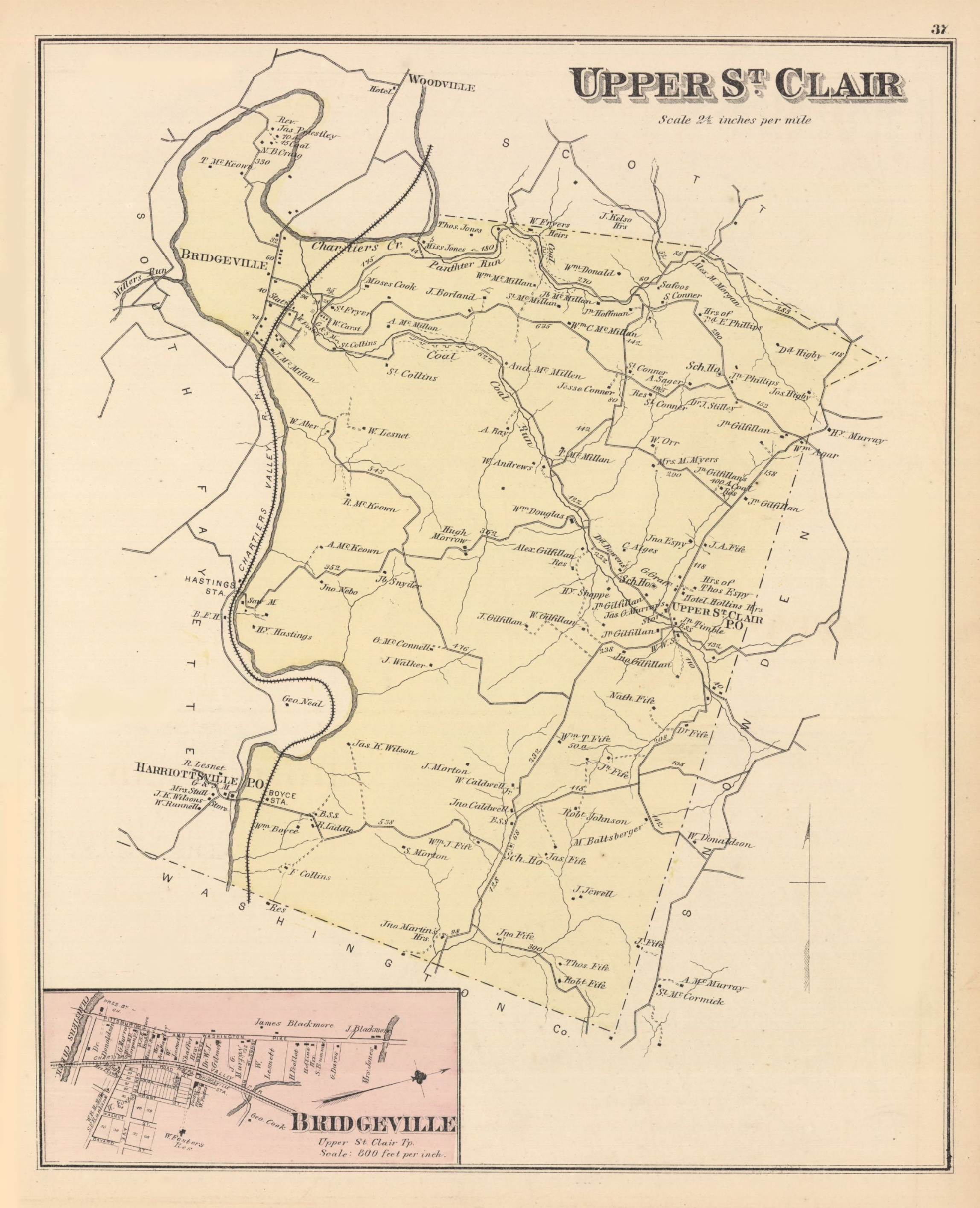 1876 — G.M. Hopkins Atlas of Allegheny County, Plate 37. Upper St. Clair Township with landowner names. The “J. Walker” parcel shown here sits within the boundaries of the original Wingfield patent, on land that William Walker would sell to Alexander Gilfillan in 1904.
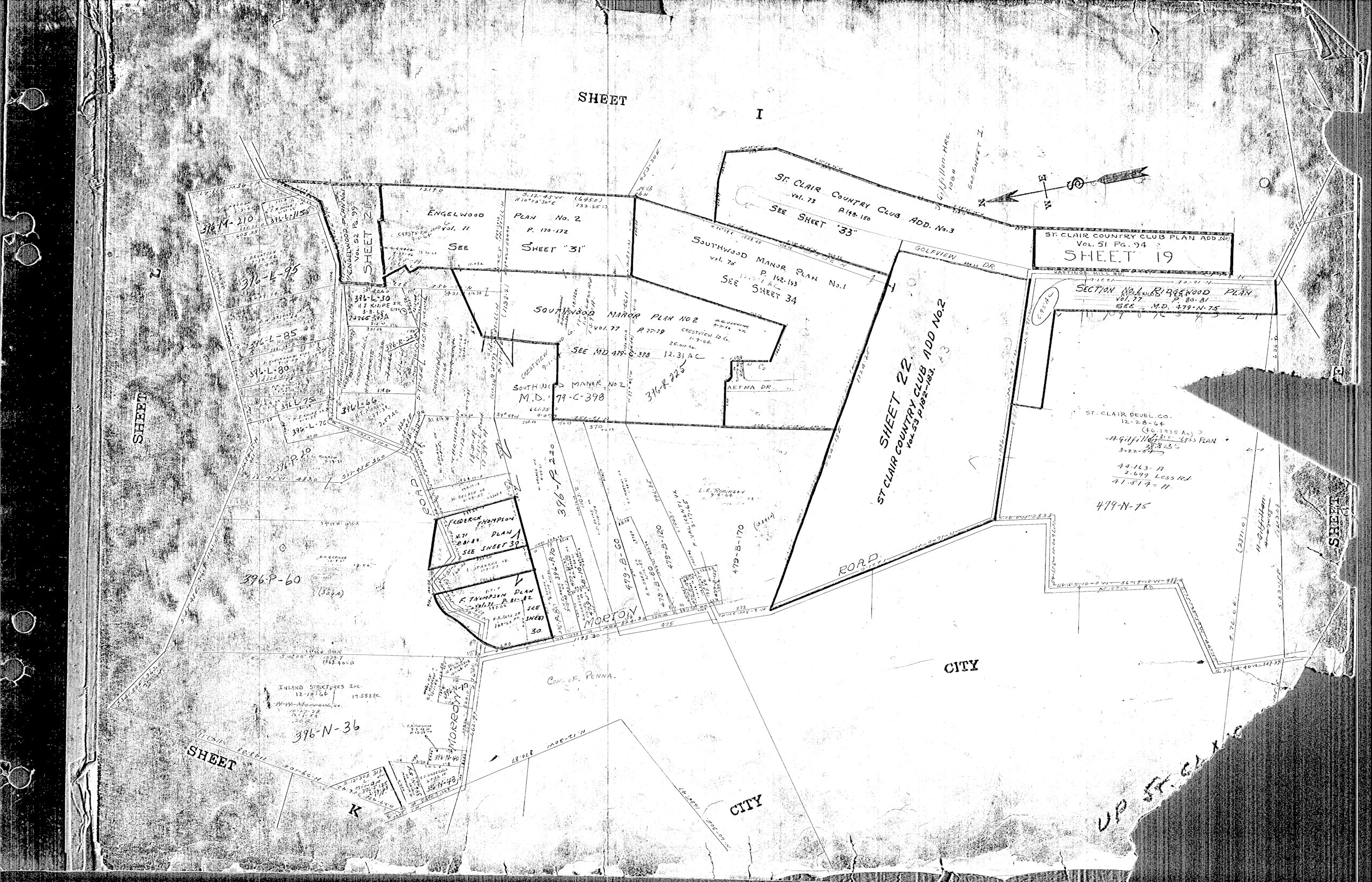 c. 1965 — Allegheny County tax-parcel survey of the area just before the Ridgewood plan was laid out, showing adjacent subdivisions (St. Clair Country Club Plan, Southwood Manor, Engelwood) and the as-yet undeveloped land that would become the neighborhood.
Further Research
For township-wide history beyond the Ridgewood Manor parcels, the Historical Society of Upper St. Clair maintains an extensive archive, including original land-patent records and an interactive map overlaying colonial-era patent boundaries on modern satellite imagery.